BOSAIMIE.jp

区切り日本語区切り中国語区切りハングル区切りポルトガル語区切りスペイン語区切りベトナム語区切りタガログ語区切り
HomeUseful Emergency InfoWeather InfoTyphoon > Projected path(Japanese region)
Useful Emergency Info
Weather Info

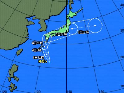
Typhoons : Projected path (Japanese region) 

│Projected path(Asian regionJapanese regionJapan zoomed view) │Storm probability
 Issued by JMA at 01:10 on Sep 03,2025
Tropical cyclone a
CurrentLocation
Location Latitude =22.2
Longitude =133.5
Area 日本の南
Size --
Strength --
Maximum wind speed 15 km/h
Direction of movement
Speed 25 km/h
Central pressure 1006 hPa
Maximum storm radius -- km
Direction of maximum storm radius --
Minimum storm radius -- km
Direction of minimum storm radius --
Maximum gale radius -- km
Direction of maximum gale radius --
Minimum gale radius -- km
Direction of minimum gale radius --
Information on forecast center position
Date and time of forecas 09/03/2025 12:00
Location Latitude =25.1
Longitude =131.8
Maximum wind speed 15 km/h
Direction of movement 北北西
Central pressure 1004 hPa
Radius from the forecast center position 100 km
Maximum storm warning radius -- km
Direction of maximum storm warning radius --
Minimum storm warning radius -- km
Direction of minimum storm warning radius --
Copyright(C) Mie Prefecture, All Rights Reserved.
Department of Disaster Prevention, Mie Prefecture