Useful Emergency Info
Weather Info
|
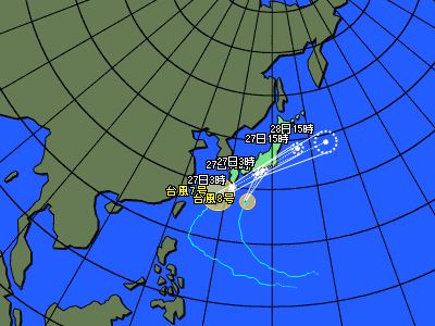
Typhoons : Projected path (Asian region)
|
■ Issued by JMA at 16:45 on Jun 26,2026
| CurrentLocation |
| Location |
Latitude =28.1
Longitude =128.1
|
| Area |
奄美市の西約140km |
| Size |
-- |
| Strength |
-- |
| Maximum wind speed |
20 km/h |
| Direction of movement |
北東 |
| Speed |
20 km/h |
| Central pressure |
990 hPa |
| Maximum storm radius |
-- km |
| Direction of maximum storm radius |
-- |
| Minimum storm radius |
-- km |
| Direction of minimum storm radius |
-- |
| Maximum gale radius |
330 km |
| Direction of maximum gale radius |
-- |
| Minimum gale radius |
-- km |
| Direction of minimum gale radius |
-- |
|
| Information on forecast center position |
| Date and time of forecas |
-- |
| Location |
Latitude =--
Longitude =--
|
| Maximum wind speed |
-- km/h |
| Direction of movement |
-- |
| Central pressure |
-- hPa |
| Radius from the forecast center position |
-- km |
| Maximum storm warning radius |
-- km |
| Direction of maximum storm warning radius |
-- |
| Minimum storm warning radius |
-- km |
| Direction of minimum storm warning radius |
-- |
|
 |
| CurrentLocation |
| Location |
Latitude =27.6
Longitude =134.1
|
| Area |
日本の南 |
| Size |
-- |
| Strength |
-- |
| Maximum wind speed |
23 km/h |
| Direction of movement |
北 |
| Speed |
50 km/h |
| Central pressure |
998 hPa |
| Maximum storm radius |
-- km |
| Direction of maximum storm radius |
-- |
| Minimum storm radius |
-- km |
| Direction of minimum storm radius |
-- |
| Maximum gale radius |
220 km |
| Direction of maximum gale radius |
東 |
| Minimum gale radius |
110 km |
| Direction of minimum gale radius |
西 |
|
| Information on forecast center position |
| Date and time of forecas |
06/27/2026 03:00 |
| Location |
Latitude =33.9
Longitude =137.7
|
| Maximum wind speed |
25 km/h |
| Direction of movement |
北北東 |
| Central pressure |
996 hPa |
| Radius from the forecast center position |
85 km |
| Maximum storm warning radius |
-- km |
| Direction of maximum storm warning radius |
-- |
| Minimum storm warning radius |
-- km |
| Direction of minimum storm warning radius |
-- |
|
Copyright(C) Mie Prefecture, All Rights Reserved.
Department of Disaster Prevention, Mie Prefecture