|
Mie is one of the heaviest rainfall areas, especially areas in the southern part of the prefecture, ranging from Owashi to Odaigahara, with rainfall of 3000-4000mm. Characteristically, heavy rainfall occurs within a short time period in this region. Also, Mie is often in the path of typhoons due to its geographical location, and major typhoons have occurred in the past.
The table shows the main rainfall disasters that have caused major damage in Mie since the war.
|
 |
Date of Disaster
|
Type of Disaster
|
Deaths & Injuries
(Number of people)
|
Damage to Buildings
|
Deceased
|
Missing
|
Injuries
|
Completely Destroyed/
Completely Destroyed by Fire
|
Partially Destroyed/
Partially Destroyed by Fire
|
Lost due to Flooding
|
Houses Flooded
|
Partially Damaged
|
|
Sep 25, 1953
|
Typhoon No. 13
|
44 |
6 |
2491 |
1282 |
4953 |
436 |
69626 |
|
|
Sep 26, 1959
|
Isewan Typhoon
|
1233 |
48 |
5688 |
5386 |
17786 |
1399 |
62655 |
|
|
Sep 9–10, 1971
|
Localized downpours in South Mie
|
42 |
|
39 |
66 |
33 |
|
1762 |
8 |
Jul 11– Aug 3,
1982
|
Storms and heavy rain due to seasonal rain front, Typhoon No. 11, and low pressure
|
22 |
2 |
31 |
69 |
105 |
|
11405 |
76 |
|
Sep 10, 2000
|
Downpour
|
1 |
|
1 |
|
2 |
|
3189 |
|
|
|
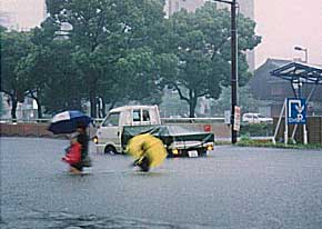
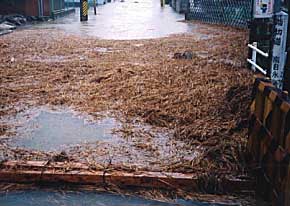
Recent rainfall disasters causing major damage include the Tokai Rainfall Disaster, which occurred on Sept 10, 2000, due to the effect of Typhoon No. 14 and the Autumn rain front. The Tokai Rainfall Disaster is fresh in our minds as having caused major disasters such as river flooding around Nagoya in Aichi, however, it has also caused major damage in Mie.
From the night of Sept 10, 2000, heavy rain fell in various areas of Mie, and heavy rain and flood warnings were announced in all areas of the prefecture, excluding Iga region. The amount of rainfall measured from when it started raining was recorded as 501mm in Miyagawa being the highest in the prefecture, and also 331mm in Kuwana City. In the Tomita district of Yokkaichi City, river flooding caused houses to be flooded above floor level, and evacuation calls were announced in all areas. Also, rockslides occurred at 9 sites, and traffic was stopped on many roads. In terms of public transport, there were many instances of trains and busses not operating, causing a large impact on those travelling to and from school. Additionally, 25 schools in the prefecture were closed.
|
|
 |
|
 |
|
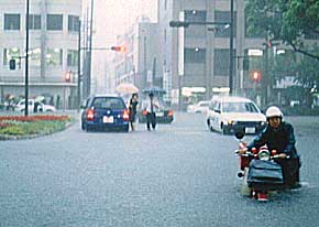
Central street in front of the Museum, Yasujima 1chome, Yokkaichi City
|
|
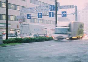
National Route 1, Suwa, Yokkaichi City
|
 |
|
 |
|
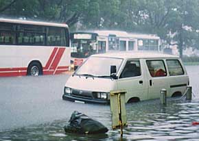
Central street in front of the former JUSCO, Suwa-sakae, Yokkaichi City
|
|
Central street in front of the former JUSCO, Suwa-sakae, Yokkaichi City
|
 |
|
 |
|
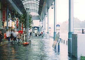
Central street, Suwa-sakae, Yokkaichi City
|
|
Railroad Crossing inside Kintetsu, Hinaga, Yokkaichi City
|
|
Provide by Disaster Prevention Section, General Administration Department, Yokkaichi Town Hall
|
|


