Disaster Prevention Resources
Landslide Preparedness
|
Erosion Disasters in the past
|
Mie has geographical and geological features which are prone to erosion disasters. We had heavy rainfall due to a rain front and typhoons in the past, in various parts of the prefecture, resulting in large-scale disasters claiming precious lives and property. The table shows a list of the main disasters that have occurred in the past.
|
Date |
Event |
Location and details |
1953 |
Higashi Kinki Flood, Typhoon No. 13 |
Shimagahara |
1959 |
Ise-wan Typhoon |
1,281 people dead and missing |
1971 |
Nanbu heavy rain |
Owase, Kumano |
1976 |
Typhoon and storm |
Iitaka, Iinan |
1982 |
Typhoon and storm |
Misugi, Ureshino |
1991 |
Typhoon and storm |
Kumano |
1992–1993 |
Typhoon and storm |
Owase, Ayama |
1999 |
Typhoon and storm |
Fujiwara (current Inabe City)
Erosion control dam stopped a mud flood. |
 |
 |
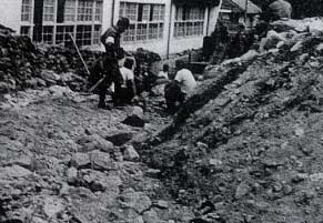
1959 Ise-wan Typhoon
Utani river (Misugi)
|
1982 Typhoon No.10 and storm
Kakiuchi river (Ureshino)
|
|
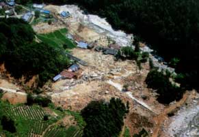
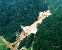
The mud flood of July 17th, 2002.
|
On July 17th, 2002, a mud flood occurred in Fujiwara (current name Inabe city) due to heavy rainfall caused by low air pressure. Most of the mudslide was stopped by the sediment control dam. No deaths or injuries were caused, however, some buildings were damaged. The figure is an aerial photo at the time.
|
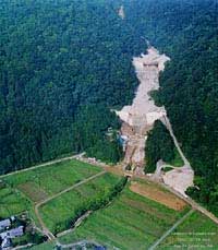
The Nishinogaito river and five sediment control dams (1)
|
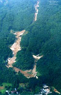 |
The photo clearly shows that the five dams stopped the mud flood.
All of the four dams at the mainstream were filled with mud and rocks, however, the dam on the left branch stream was not filled. At the bottom of the photograph are the houses in the Ogaito area. In the mud flood which occurred in August and September 1999, there was only one sediment control dam available, and the mud floods progressed approximately 100m from these houses.
|
The Nishinogaito river and five sediment control dams (2)
|
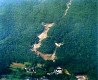 |
The photo shows that the upstream dams shut out larger rocks more effectively than the downstream ones. At the bottom of the photograph are houses in the Ogaito area. The uppermost sediment control dam has changed shape due to the mud flood.
|
The Otaki river and two sediment control dams (1)
|
 |
The upstream sediment control dam has a slit made of steel, and this has trapped huge rocks and driftwood. A secondary dam is currently under construction for the downstream dam.
|
The Otaki river and two sediment control dams (2)
|
 |
The left hand side of the photo shows housing in Sakamoto district, however damages to these houses are not apparent in this photo.
|
|
Photos provided by Asia Air Survey Co. Ltd.
|
|
|
Erosion Disasters in the past
|
|
Mie has geographical and geological features which are prone to erosion disasters. We had heavy rainfall due to a rain front and typhoons in the past, in various parts of the prefecture, resulting in large-scale disasters claiming precious lives and property. The table shows a list of the main disasters that have occurred in the past.
|
|
Date
|
Event
|
Location and details
|
|
1953
|
Higashi Kinki Flood, Typhoon No. 13
|
Shimagahara
|
|
1959
|
Ise-wan Typhoon
|
1,281 people dead and missing
|
|
1971
|
Nanbu heavy rain
|
Owase, Kumano
|
|
1976
|
Typhoon and storm
|
Iitaka, Iinan
|
|
1982
|
Typhoon and storm
|
Misugi, Ureshino
|
|
1991
|
Typhoon and storm
|
Kumano
|
|
1992–1993
|
Typhoon and storm
|
Owase, Ayama
|
|
1999
|
Typhoon and storm
|
Fujiwara (current Inabe City)
Erosion control dam stopped a mud flood.
|
|
|
|
1959 Ise-wan Typhoon
Utani river (Misugi)
|
|
|
|
1982 Typhoon No.10 and storm
Kakiuchi river (Ureshino)
|
|
The mud flood of July 17th, 2002.
|
|
On July 17th, 2002, a mud flood occurred in Fujiwara (current name Inabe city) due to heavy rainfall caused by low air pressure. Most of the mudslide was stopped by the sediment control dam. No deaths or injuries were caused, however, some buildings were damaged. The figure is an aerial photo at the time.
|
|
The Nishinogaito river and five sediment control dams (1)
|
|
The photo clearly shows that the five dams stopped the mud flood.
All of the four dams at the mainstream were filled with mud and rocks, however, the dam on the left branch stream was not filled. At the bottom of the photograph are the houses in the Ogaito area. In the mud flood which occurred in August and September 1999, there was only one sediment control dam available, and the mud floods progressed approximately 100m from these houses.
|
|
|
|
The Nishinogaito river and five sediment control dams (2)
|
|
The photo shows that the upstream dams shut out larger rocks more effectively than the downstream ones. At the bottom of the photograph are houses in the Ogaito area. The uppermost sediment control dam has changed shape due to the mud flood.
|
|
|
|
The Otaki river and two sediment control dams (1)
|
|
The upstream sediment control dam has a slit made of steel, and this has trapped huge rocks and driftwood. A secondary dam is currently under construction for the downstream dam.
|
|
|
|
The Otaki river and two sediment control dams (2)
|
|
The left hand side of the photo shows housing in Sakamoto district, however damages to these houses are not apparent in this photo.
|
|
|
|
Photos provided by Asia Air Survey Co. Ltd.
|
|
Copyright(C) Mie Prefecture, All Rights Reserved.
Department of Disaster Prevention, Mie Prefecture


